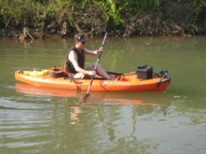
Several environmental agencies such as the U.S. Forest Service used data collected and analyzed by Dr. Paul Ayers’s research group for a wide variety of projects. Some examples are mapping and documenting coal movement in the East Tennessee River system, documenting invasive species such as Hydrilla in the river system, locating endangered species habitat like the Dusky Tail Darter, and mapping the condition and quality of river banks. A typical dataset looks like a Google Street View map but on a river and some data sets are underwater. Data was collected using a kayak system equipped with several above and below water video cameras, GPS, other sensors and data logging devices.
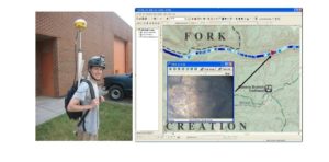
I participated in the data collection efforts which require rapid and organized data management techniques. I also translated video into geospatial data for further analysis. I also designed two separate video mapping systems as part of this work. The first was a video mapping system which could be used on a bicycle or a hiking arrangement for mapping trails. It used some of the same components as the kayak system, but had to be much more compact and lighter. I also designed a river width measurement system using two laser range finders which was used in conjunction with video for river bank monitoring.